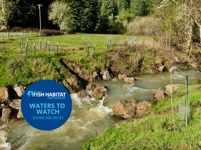
Upper Green Valley Creek Fish Passage Project
In 2019 this project was selected as one of NFHP’s annual list of 10 Waters to Watch. Learn more here.
Project Update: July 2018
Project Lead: Gold Ridge Resource Conservation District
Location of Project: 38.45150, -122.92725
Description of Project: The goal of the project is to restore fish passage and stabilize the grade through a 600-ft stream reach of upper Green Valley Creek (a tributary to the Russian River), thereby ensuring passage for juvenile and adult coho to an additional 4,810 ft of rearing and spawning habitat.
Green Valley Creek, a major tributary to the lower Russian River, provides critical habitat for remnant native populations of coho salmon and steelhead trout, particularly in its upper portions. The Recovery Strategy for California Coho Salmon (CDFG, 2004) identified the Guerneville HSA as having the highest ranking (level 5) for restoration and management potential in the CCC Coho ESU, while NMFS’ CCC Coho Salmon Recovery Plan identified Green Valley Creek as a Phase I Priority area, with a goal for near-term population recovery. Green Valley Creek was one of only three Russian River tributaries in which coho salmon were recorded in the early 2000s. Thus, it has been a focus watershed for DFW’s coho recovery program, for the Russian River Coho Water Resources Partnership, and for the Russian River Coho Salmon Captive Broodstock Program. The Broodstock Program has been stocking juvenile coho into Green Valley Creek (including the reach that contains the project site) since 2006.
While holding high potential for salmonid recovery, the Green Valley Creek Watershed continues to face a number of potential limiting factors to fisheries success, including sedimentation, channel incision, and fish passage barriers. CDFW has documented a decline in salmonid habitat conditions in the Upper Green Valley system, and this decline has been accompanied by a collapse in both coho and steelhead populations. Previous studies, culminating in the Green Valley Creek Watershed Management Plan Phase II Draft (GRRCD, 2013) have evaluated habitat impairments and potential limiting factors to fisheries success and have pointed to the impact of instream fish passage barriers (GRRCD, 2013; CDFG 1995, 2006; Laurel Marcus and Associates 2002; Merritt Smith 2003).
Description of why this barrier is a high priority project: The barrier consists of an undersized, failing private road culvert, whose inlet invert sits 11.5 ft above the outlet pool depth. The culvert is serving as tenuous grade control for deep and rapid channel incision, and its imminent failure threatens to unzip the valley above, disconnecting its floodplains and exacerbating fine sediment loads plaguing spawning gravels downstream. The reach upstream of the project area, which is currently inaccessible to coho under all flow conditions, is low gradient and unincised, and has many attributes of high-quality coho rearing habitat, including year-round flow, with intermediate spawning habitat. The project would also ensure grade stabilization through this valuable reach, preserving floodplain connectivity and arresting downcutting. To both restore fish passage at all flow conditions for all life stages, the project will replace the rusted undersized culvert with a bottomless arch culvert, create a 157-ft long step-pool roughened channel through the crossing, and construct two series of boulder weirs on either end. Finally, the riparian corridor throughout the 600-ft reach, an area comprising over 1.1 acres, will be revegetated with over 650 native plants, maintained for 3 years to 80% survival rates.
The name(s) of the recovery plans and the specific task that name this barrier as a high priority: This project has been identified as a fish passage barrier in the Green Valley Creek Stream Inventory Report (DFG, revised 2006), the Green Valley Creek Watershed Assessment and Erosion Prevention Planning Project (PWA, 2008), Green Valley Creek Watershed Management Plan Phase II Draft (GRRCD, 2013), the Passage Assessment Database (#716534), and by DFW fisheries biologists (Berryman and Acomb, Green Valley Creek Culvert Analysis, 2015).
The California Fish Passage Forum has nine overall objectives. This project will help to address:
- Remediate barriers to effective fish migration.
- Promote state and national policy and actions that support fish passage improvement in California.
- Implement education and outreach activities, targeting both the general public and fish passage practitioners.
Anadromous fish species that benefit from this project: Coho salmon, Steelhead/rainbow trout
Miles of stream opened as a result of project implementation: 0.9 miles.
Location and distance in stream miles to downstream river structures, and whether each structure represents an insignificant, partial, or total barrier to fish passage: Instream dams 0.3 and 0.7 miles below the project site (PAD #716533 and #716532) are currently being addressed by the Russian River Coho Water Resources Partnership. The Green Valley Road county culvert 0.75 miles downstream of the project site, prioritized in Ross Taylor’s 2003 inventory of county road crossings, was recently modified for fish passage. Designs have been completed for two partial barriers over 4 miles downstream (#712804 and #735259), with implementation funding pending from FRGP. Additional barriers identified in the PAD as “unknown passage status” have not been prioritized by subsequent barrier assessments.
Location and distance in stream miles to upstream river structures, and whether each structure represents an insignificant, partial or total barrier to fish passage: Three other potential instream barriers upstream of the project site (PAD #716535, 716536, 758552) were analyzed in a barrier analysis conducted in 2015 by DFW staff (T.Berryman and D.Acomb). The analysis concluded that #716535, 1,200 ft above the proposed site, and two additional culvert sites not listed in the PAD, are not passage barriers. PAD site #716536, a box concrete culvert 2,180 ft above the proposed site, requires only a relatively simple fix to raise the tail water control to ensure passage. GRRCD staff are currently working with DFW staff to address that site. Remediation of Site #758552 is included in the proposed project.
How will the project be evaluated and measured for success: This project has a monitoring plan to assess success in achieving deliverables.