This project addresses two fish passage barriers on Conner Creek, a tributary to the Trinity River below Lewiston Dam. The Trinity River is a major tributary to the Klamath River. The project sites — Conner Creek Road (Crossing #1) and Red Hill Road (Crossing #2) — are located approximately 8 miles west of Weaverville in Trinity County, California.
Historical Presence of Anadromous Fish: Conner Creek supports federally threatened Southern Oregon/Northern California Coast (SONCC) coho salmon and Klamath Mountains Province (KMP) steelhead. Steelhead are the primary species documented in the immediate project area. Coho salmon have not been documented above Crossing #1, likely due to flow conditions at the Trinity River confluence and natural downstream gradient; however, reaches upstream of Crossing #2 include designated coho critical habitat.
Project Lead Organization: Five Counties Salmonid Conservation Program (5C) / Northwest California Resource Conservation and Development Council
Project Partners: California Coastal Conservancy; U.S. Fish & Wildlife Service; NOAA/National Association of Counties (NACo); U.S. Forest Service/National Fish and Wildlife Foundation; U.S. Bureau of Reclamation–Trinity River Restoration Program; Trinity County Department of Transportation (TCDOT); LanMark Forestry; California Department of Fish and Game (Fisheries Restoration Grant Program)
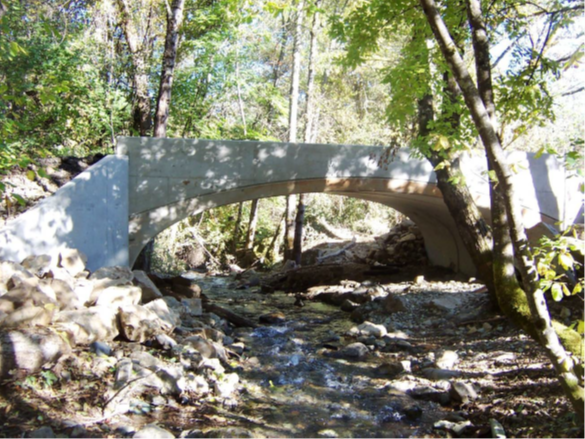
Project Description: Prior to the project, two undersized county road culverts on Conner Creek Road and Red Hill Road were complete or partial barriers to adult and juvenile salmonids, blocking access to approximately 2.5 miles of spawning and rearing habitat. The 2008 Eagle Fire, which burned the upper 42% of the watershed, increased risks of large flows and debris transport, prompting a redesign from culvert retrofit to full stream simulation crossings. The project replaced the concrete box culvert at Conner Creek Road with a 24-foot span precast ConSpan arch bridge in 2011, with the Red Hill Road crossing slated for replacement in 2012. The new structures comply with NOAA/NMFS fish passage criteria and are designed to pass 100-year flood flows and associated debris.
Completion: Fall 2011 (Crossing #1 – Conner Creek Road); Summer 2012 (Crossing #2 – Red Hill Road)
Project Effectiveness: The replacement of Crossing #1 immediately opened approximately 0.20 miles of quality spawning and rearing habitat, with the full 2.5-mile benefit contingent on completion of Crossing #2. The project also prevented 250 cubic yards of road fill from entering the stream. Post-project monitoring included photo documentation, longitudinal channel profile surveys (planned for December 2011, spring 2012, 2013, and 2014), and biological spawning/presence-absence surveys.