Kelly Gulch Fish Passage Project
Location of Project: 41°17’30” 123°10’0”
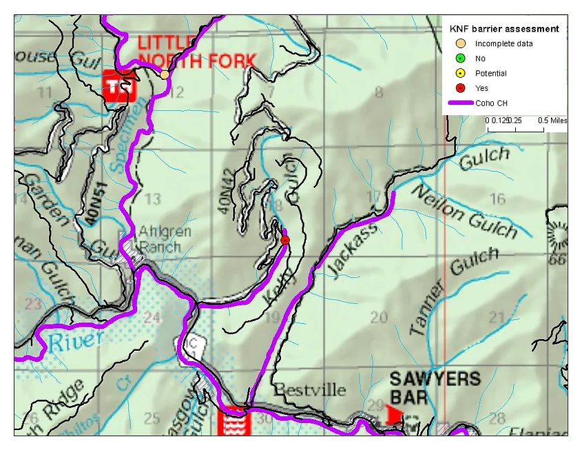
Description of Project: Kelly Gulch is a perennial tributary of the North Fork Salmon River that contains Southern Oregon and Northern California Coast (SONCC) coho salmon, Klamath Mountains Province steelhead trout and potentially Pacific lamprey, along with resident cold water fishes. Klamath National Forest data show that anadromous fish distribution in Kelly Gulch extends to the culvert at FS Road 40N39 road crossing. This culvert is a known fish passage barrier. The Kelly Gulch drainage burned during the 2013 Salmon River Complex. This culvert and two others in the drainage were surveyed by the Salmon River Complex Burned Area Emergency Recovery (BAER) Team after fire suppression activities in the Salmon River Complex Fires were completed. The team reconfirmed that this culvert is undersized, with aggradation at and above the inlet suggesting that passage of sediment and other watershed products was already hindered prior to the fire. The blockage risk is a concern, especially given the channel bend at the inlet and lack of an end section to funnel incoming debris. The drainage upstream of this culvert includes moderate burn severity, which will likely lead to an increase of discharge and debris during high flow events. As part of the BAER process, this culvert was again recommended to be upgraded to a bottomless arch culvert of appropriate size and configuration to pass the flows and debris expected post-fire as well as to address aquatic organism passage concerns. Unfortunately BAER funds were not granted for the bottomless arch upgrade; funds were granted for emergency repair in the watershed including installation of critical dips and cleaning out of road drainage features. Although the emergency repair has occurred the crossing remains a fish passage barrier. The recommended treatment is to install a bottomless arch culvert to allow natural passage of aquatic organisms, water, sediment, and debris through the system. The upgrade would extend the range of coho salmon designated critical habitat. An additional 0.4 miles of spawning and rearing habitat for anadromous fish including SONCC coho salmon and steelhead trout upstream of this culvert would become accessible.
Description of why this this barrier is a high priority project: Barrier is listed in a key restoration plan for the region (see question number 8 below); Endorsed by agency; Local knowledge/conversation with local representatives
The name(s) of the recovery plans and the specific task that name this barrier as a high priority: KNF 2001 road stream crossing inventory identified this site as RED – passage barrier to all life stages and all/most flows. SONCC coho salmon recovery plan – Recovery action SONCC-SalR.5.1.9 identifies the need to address the few remaining road stream crossing barriers in the watershed. Also, the barrier has been identified in the Salmon River Restoration Council Riparian Assessment and Salmon River Complex BAER Team Final Report.
The California Fish Passage Forum has nine overall objectives. This project will help to address: 1. Remediate barriers to effective fish migration.; 3. Identify, assess and prioritize the removal of fish passage barriers.; 7. Facilitate plans to monitor and evaluate fish passage restoration effectiveness to ensure accountability. Because this crossing is one of the only remaining barriers to anadromous fish on the Klamath National Forest Transportation System, it is a top priority for upgrade. The Forest Service and Salmon River Restoration Council will actively monitor the site to ensure passage objectives are met in the short and long term.
Anadromous fish species that will benefit from project: Coho salmon; Steelhead/rainbow trout; Pacific lamprey
Location and distance in stream miles to downstream river structures, and whether each structure represents an insignificant, partial, or total barrier to fish passage: About one mile downstream a bridge was placed over Kelly Gulch at Siskiyou County Road 1C01 crossing to address fish passage concerns around 2006. Legal location: T40N, R12W, Sec 24, NE1/4. The bridge is not a barrier to fish passage.
Location and distance in stream miles to upstream river structures, and whether each structure represents an insignificant, partial, or total barrier to fish passage: About 0.5 mile upstream a culvert at FS Road 40N42 road crossing is a total barrier to fish passage. Legal location: T40N, R11W, Sec 18 NW1/4. However Kelly Gulch is an intermittent stream at this point. A different fork of Kelly Gulch has more perennial flow; in that fork approximately 0.75 miles upstream is another culvert that is probably a total barrier to fish passage.
How the project will be evaluated and measured for success: The project will be monitored to determine if anadromous fish are accessing the habitat made accessible upstream of the project. A section of Kelly Gulch beginning from the upstream end of the culvert and extending approximately 0.4 miles upstream will be surveyed to determine if juvenile SONCC coho salmon and/or steelhead trout are present in this section. The new crossing will be monitored during and after high flow events to ensure that the passage of watershed products at the site is functional and sustainable.